|
As of 02:00 PM December 24, 2019,
"Ursula" Intensifies Into A Typhoon As It Endangers Eastern Visayas. At 1:00 PM today, the eye of Typhoon "URSULA" was located based on all available data including Guiuan Doppler Radar at 95 km East of Guiuan, Eastern Samar (11.0 °N, 126.6 °E ), moving West at 20 kph with maximum sustained winds of 120 kph near the center and gustiness of up to 150 kph.
Heavy Rainfall Outlook
Between today and tomorrow noon: Occasional to frequent heavy rains over Dinagat Islands, Siargao and Bucas Grande Islands, Eastern Visayas, Sorsogon, Masbate, northern and central Cebu, northern Negros Provinces, Aklan, Antique, Capiz, Iloilo, Guimaras and Romblon. Light to moderate with intermittent heavy rains over the rest of Bicol Region, Quezon, Marinduque, Oriental Mindoro, and the rest of Visayas and Surigao del Norte. Between tomorrow noon and late evening: Occasional to frequent heavy rains over Aklan, Antique, Capiz, Romblon, Marinduque, Oriental Mindoro, Occidental Mindoro, Batangas, and Calamian Islands. Light to moderate with intermittent heavy rains over Cuyo Islands, Negros Provinces, Iloilo, Guimaras, Aurora, and the rest of CALABARZON. Residents in these areas are advised to take appropriate measures to reduce the potential impact of flooding and rain-induced landslides, especially in areas identified to be highly to very highly susceptible to these hazards. Tropical Cyclone Winds: Moderate to strong winds to begin affecting Northeastern Mindanao and Eastern Visayas today; Bicol Region and portions of Central Visayas this afternoon or tonight; CALABARZON, and portions of MIMAROPA and Western Visayas tomorrow morning; Metro Manila, Bulacan, and Bataan tomorrow morning or afternoon. Medium to high-risk structures may experience light damage. Damaging gale to storm-force winds to begin affecting areas under Tropical Cyclone Wind Signal (TCWS) #2 in Southern Leyte this afternoon; in Albay, Sorsogon, Masbate, Romblon, Aklan, Capiz and portions of Antique, Iloilo, and northern Cebu tonight; in Marinduque, southern portion of Quezon, portions of Mindoro Provinces tomorrow morning. This may bring light to moderate damage to high-risk structures and at most light damage to medium-risk structures. Destructive typhoon force winds to begin affecting areas under TCWS #3 this afternoon. High-risk structures may experience heavy damage. Other Hazards and Warning Information: "URSULA" is forecast make to landfall over Borongan-Guiuan area b etween 4:00 PM to 6:00 PM today. Storm Surge of up to 2.0 meters may affect the several coastal areas of Eastern Samar, Northern Samar, and Leyte. Rough sea conditions will prevail starting today over the eastern seaboards of the country; this afternoon or tonight over the inland waters of Southern Luzon and Visayas; tomorrow afternoon over the western seaboards of Southern Luzon. Sea travel is risky over these areas. Source: http://bagong.pagasa.dost.gov.ph/tropical-cyclone/severe-weather-bulletin/2
0 Comments
At 4:00 AM today,
the center of Severe Tropical Storm "URSULA" was estimated based on all available data including Guiuan Doppler Radar at 315 km East of Guiuan, Eastern Samar (10.8 °N, 128.6 °E ). Moving West Northwest at 30 kph with maximum sustained winds of 95 kph near the center and gustiness of up to 115 kph. URSULA INTENSIFIES INTO A SEVERE TROPICAL STORM
Heavy Rainfall Outlook
Between today and tomorrow noon: Occasional to frequent heavy rains over Dinagat Islands, Siargao and Bucas Grande Islands, Eastern Visayas, Sorsogon, Masbate, northern and central Cebu, northern Negros Provinces, Aklan, Antique, Capiz, Iloilo, Guimaras and Romblon. Light to moderate with intermittent heavy rains over the rest of Bicol Region, Quezon, Marinduque, Oriental Mindoro, and the rest of Visayas and Surigao del Norte. Between tomorrow noon and late evening: Occasional to frequent heavy rains over Aklan, Antique, Capiz, Romblon, Marinduque, Oriental Mindoro, Occidental Mindoro, Batangas, and Calamian Islands. Light to moderate with intermittent heavy rains over Cuyo Islands, Negros Provinces, Iloilo, Guimaras, Aurora, and the rest of CALABARZON. Residents in these areas are advised to take appropriate measures to reduce the potential impact of flooding and rain-induced landslides, especially in areas identified to be highly to very highly susceptible to these hazards. Tropical Cyclone Winds: Moderate to strong winds to begin affecting Northeastern Mindanao and Eastern Visayas this morning or noon; Bicol Region and portions of Central Visayas this afternoon or tonight; CALABARZON, and portions of MIMAROPA and Western Visayas tomorrow morning; Metro Manila, Bulacan, and Bataan tomorrow morning or afternoon. Medium to high-risk structures may experience light damage. Damaging gale to storm-force winds to begin affecting areas under TCWS#2 in Eastern Visayas this afternoon; in Albay, Sorsogon, Masbate, and portions of Capiz, Iloilo, and northern Cebu tonight. This may bring light to moderate damage to high-risk structures and at most light damage to medium-risk structures. Other Hazards and Warning Information: "URSULA" is forecast make to landfall over Eastern Samar this afternoon or evening. The highest Tropical Cyclone Wind Signal (TCWS) that can be raised at the moment is TCWS #2. However, potential intensification into a Typhoon prior to landfall or while crossing the inland seas of the country is not yet ruled out. As such, there remains a possibility of hoisting TCWS #3. Suspension of maritime activities may be experienced in areas where TCWS are in effect. Rough sea conditions will prevail starting today over the eastern seaboards of the country; this afternoon or tonight over the inland waters of Southern Luzon and Visayas; tomorrow afternoon over the western seaboards of Southern Luzon. Sea travel is risky over these areas. Source: http://bagong.pagasa.dost.gov.ph/tropical-cyclone/severe-weather-bulletin/2
An icy stretch of a Virginia highway, all westbound lanes of Interstate 64 in York County
witnessed a 63-vehicle pileup that left 35 people injured on December 22. Bad weather to blame for the pileup but if you read the comments, something else is to blame too. "I see people drive like idiots all the time on the interstate like people flying right behind me. speeding around me only to slam on their brakes because there's cars in front. I'm not sure if people dont understand how dangerous driving is you are controlling a heavy machine that can kill people and kill yourself. maybe its they dont know or they just dont care about dying". Well, there are really reckless drivers anywhere in the world may it be good weather or bad. They just want to speed up much, thus traveling in harm's way. Tailgating too is to blame. One should maintain a safe distance from another vehicle.
Whakaari/White Island
is an active andesite stratovolcano situated 48 km (30 mi) from the east coast of the North Island of New Zealand, in the Bay of Plenty. It is a popular tourist destination where access or visit to the island is only allowed as a member of a tour run by a registered tour operator. A small charter fleet, offering day trips and overnight or longer trips, operates from the nearby port at Whakatane. On December 9, it erupted while there were reportedly 47 visitors on the island. Reports were of about 16 fatalities and 31 injured with severe burns. Source: https://en.wikipedia.org/wiki/Whakaari%2FWhite_Island 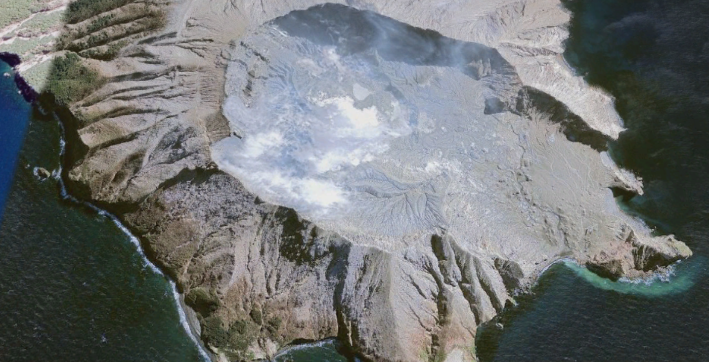
Whakaari/White Island on Google Earth Pro
|
Earth Blog
These are articles, stories and events that happen in this world that make impact on every nation and race.
Other Blogs
Archives
December 2023
|
 RSS Feed